Which countries are most densely populated?
To understand people’s geographical distribution, we need to look at population density. How does this vary across the world?
Geographical maps often shape our understanding of the world, but they tell us nothing about where people live. To understand this, we need to look at population density.
Population density measures how densely populated an area is. It is calculated by dividing the total population by the area's total land area.
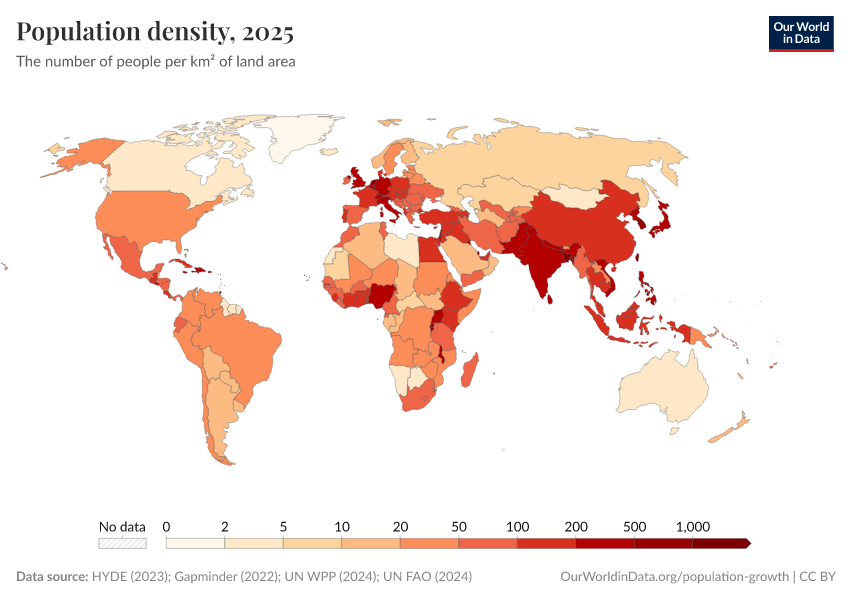
The map shows the number of people per square kilometer (km2) across countries.
Globally, the average population density is 63 people per km² in 2025, but there are very large differences across countries.
Many of the world’s small islands or isolated states have large populations for their size. The five most densely populated are Macao, Monaco, Singapore, Hong Kong, and Gibraltar. Singapore has 8177 people per km², around 200 times as dense as the United States and 2000 times as dense as Australia.
Of the larger countries1, Bangladesh is the most densely populated, with 1350 people per km². It’s followed by Rwanda (591), Lebanon (572), Burundi (560), and the Netherlands (545).
If you hover your mouse over the brackets from 0 to 10 on the legend, you can see the world's least densely populated countries. Greenland is the least dense, with around 0.14 people per km², followed by Mongolia, Australia, Namibia, and Iceland.
Another useful tool for understanding how people are distributed worldwide is the population cartogram, a geographical presentation of the world in which the size of the countries is not drawn according to the distribution of land but according to the distribution of people.
In another article, we show how the world looks in this way. When we see a standard map, we focus on the largest countries by area. But these are not always where the greatest number of people live. We need this context to understand how the lives of people around the world are changing.
Endnotes
Here, we use an arbitrary cut-off of 10,000 square kilometers to define a "large" country.
Cite this work
Our articles and data visualizations rely on work from many different people and organizations. When citing this article, please also cite the underlying data sources. This article can be cited as:
Hannah Ritchie and Edouard Mathieu (2019) - “Which countries are most densely populated?” Published online at OurWorldinData.org. Retrieved from: 'https://ourworldindata.org/most-densely-populated-countries' [Online Resource]BibTeX citation
@article{owid-most-densely-populated-countries,
    author = {Hannah Ritchie and Edouard Mathieu},
    title = {Which countries are most densely populated?},
    journal = {Our World in Data},
    year = {2019},
    note = {https://ourworldindata.org/most-densely-populated-countries}
}
Reuse this work freely
All visualizations, data, and code produced by Our World in Data are completely open access under the Creative Commons BY license. You have the permission to use, distribute, and reproduce these in any medium, provided the source and authors are credited.
The data produced by third parties and made available by Our World in Data is subject to the license terms from the original third-party authors. We will always indicate the original source of the data in our documentation, so you should always check the license of any such third-party data before use and redistribution.
All of our charts can be embedded in any site.
